
The City and VDOT partnered to hold an additional engagement session on April 27, 2026 to hear community feedback on the preferred alternative. Staff developed this FAQ page to share technical explanations on design decisions and as a complement to the engagement summary shared on the VDOT Study page (linked below).
Below are answers to some common questions about the West Main and Ridge "Final Concept" as the City seeks application to VDOT for SMART SCALE project funding. If you still have questions, please feel free to contact us and we’ll get back to you as soon as possible!
The study intent was to support the VDOT Culpeper District with analysis of operations at the intersection of Ridge Street and W Main Street (BUS US-250)/ W Water Street in Charlottesville, VA. W Main Street (BUS US-250) is identified as a Potential for Safety Improvement (PSI) segment and was previously a SMART SCALE project that was subsequently cancelled due to funding constraints. The objectives of this study were to address several Virginia Transportation Plan (VTrans) needs such as bicycle, pedestrian, and transit/transportation demand management (TDM) access needs, congestion mitigation, and improving safety at the Ridge Street and W Main Street (BUS US-250)/ W Water Street intersection. Twenty-two percent (22%) of the reported crashes during the period 2019-2024 at this location involved pedestrians.
The purpose of this study was to evaluate operational, multi-modal and safety conditions and to develop improvement alternatives that will address these issues and the regional transportation needs. The advanced alternative recommended by the study was developed with identification of accessibility, congestion, and safety improvements along the corridor for all transportation users.
The STARS Study Project Working Group team for this project was comprised of VDOT staff, VDOT contracted consultant support, and City staff. Public engagement was incorporated into the design iterations from Survey #1 (existing conditions collection) and Survey #2 (feedback on preliminary alternatives). A Community Input Meeting (in January 2026) and Charlottesville Downtown Engagement session (in April 2026) were held to share the Advanced Alternative and provide a final opportunity for public review.
To apply for funds from SMART SCALE Round 7, City Council must issue a Resolution of Support before the August application deadline.
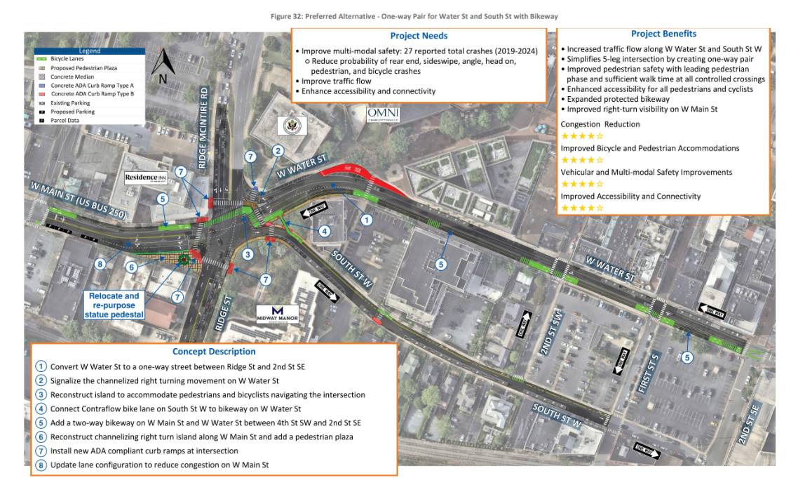
The proposed one-way operation on Water Street is a key component of the Ridge St/W Main Street intersection improvement project. The primary purpose is to simplify one of Charlottesville’s most complex and heavily traveled intersections and improve safety and multimodal connectivity for all users. The one-way pair of W Water and South St W have other benefits such as improved signal operations and progression, reduced conflict points and crashes, and a more efficient use of limited roadway space.
Overview: The bikeway is placed on the south side because it allows traffic moving east and west to run at the same time, which makes the intersection work better and reduces congestion. Putting the bikeway on the north side would create traffic delays, worsen turning movements, and make pedestrian crossings longer and less safe.
A breakdown of technical analysis is shared below:The south side placement of the bikeway was selected due to geometric and operational constraints associated with the eastbound through movement to West Main Street. A key benefit of the preferred configuration is the ability to operate the eastbound and westbound movements concurrently rather than under split phasing, resulting in improved intersection efficiency and reduced congestion.With the bikeway located on the north side, the roadway alignment shifts vehicular traffic further south, preventing the eastbound and westbound movements from operating concurrently. This would require split-phase signal operations, increasing delay and reducing overall intersection capacity.
In addition, a north-side bikeway would require a larger curb return radius at the northeast quadrant to accommodate heavy vehicle turning movements. Expanding the radius would push the Ridge McIntire Road crosswalk farther upstream and away from the signalized intersection, increasing pedestrian crossing distance and reducing the overall effectiveness of the pedestrian crossing location.
The existing configuration functions more effectively because the eastbound right-turn lane is channelized and separated from the through lanes, allowing turning vehicles to diverge prior to the primary intersection operations. Introducing a protected bike lane within this area would increase modal conflicts and complicate the turning movement geometry, particularly given the volume of right-turning vehicles.
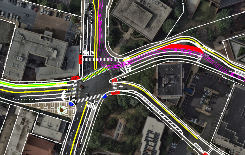
On April 27, 2026, a Charlottesville Downtown Engagement session was held to provide the final opportunity for public review of the recommended concept before the City moves to request funding through the SMART SCALE process. Key themes were accommodation of delivery vehicles serving downtown businesses, questions about siting the bi-directional bikeway on the south side of Water St, and public & tourist wayfinding to the Pedestrian Mall if Water St is made one-way.
After technical review, the final concept preserves key aspects of the preferred alternative, including a bi-directional bikeway on the south side of one-way Water St, so that the project maintains competitive advantage in the SMART SCALE application scoring process. For example, shifting the bi-directional bikeway to the north side of Water St would require a larger curb return radius at the northeast quadrant to accommodate heavy vehicle turning movements. Expanding the radius would push the Ridge McIntire Road crosswalk farther upstream and away from the signalized intersection, increasing pedestrian crossing distance and reducing the overall effectiveness of the pedestrian crossing location.
The proposed design improves multi-modal safety, improves traffic flow (versus the 2050 No-Build scenario), and enhances accessibility and connectivity. In response to community comments raised, City staff members of the STARS working group will refer concerns and recommendations outside of the scope for the STARS study and SMART SCALE funded project to the appropriate City departments.
With the Downtown Transit Station located to the east on Water Street, this corridor experiences a high propensity of transit service. High bus volumes can be safely managed with physical separation between bus activity on the north side and south-side bikeway, minimizing direct conflict points.
The proposed bikeway alignment was selected because it minimizes congestion and overall delay. The alignment allows bicyclists to traverse the intersection concurrently with eastbound and westbound traffic without introducing conflicts. Alternative alignments would create conflicts with turning vehicles, necessitating a dedicated bicycle signal phase and increasing congestion and delay.
SMART SCALE scoring evaluates delay reduction and safety improvement benefits and compares them with the construction cost. This Benefit-Cost Ratio (BCR) is a crucial scoring factor in SMART SCALE. Keeping the bikeway on the south side through the intersection would require a bike-only traffic signal phase, increase the vehicular delay, and create more conflicts at the intersection, thus impacting the BCR and SMART SCALE score.
The Downtown Engagement session raised additional issues outside the scope of the STARS study and SMART SCALE application. City staff have flagged concerns and will continue to assess opportunities to improve wayfinding to the Pedestrian Mall, address potential delays from the railroad using a "Left Turn Only" sign when the railroad is in use, and provide connected sidewalks between 1st St S and 2nd St SE.
The Advanced Alternative maintains existing conditions for on-street parking and loading zones.
The STARS Study final report represents conceptual design plans. If the City receives SMART SCALE funding for this project, the project team will undertake additional work to develop construction documents. Construction would be programmed in VDOT's Six Year Improvement Plan and design would incorporate changes to existing conditions between now and implementation.
The City plans to undertake a W Main Street planning and engagement process in advance of street repaving along that corridor, before SMART SCALE funds would be available. Community members will have an opportunity to comment on bike facilities as a part of that process.
To the east of this design, City staff have documented community interest in connecting the Water St bikeway with the Coal Tower/Meade Avenue Shared Use Path to the south of the Ting Pavilion.